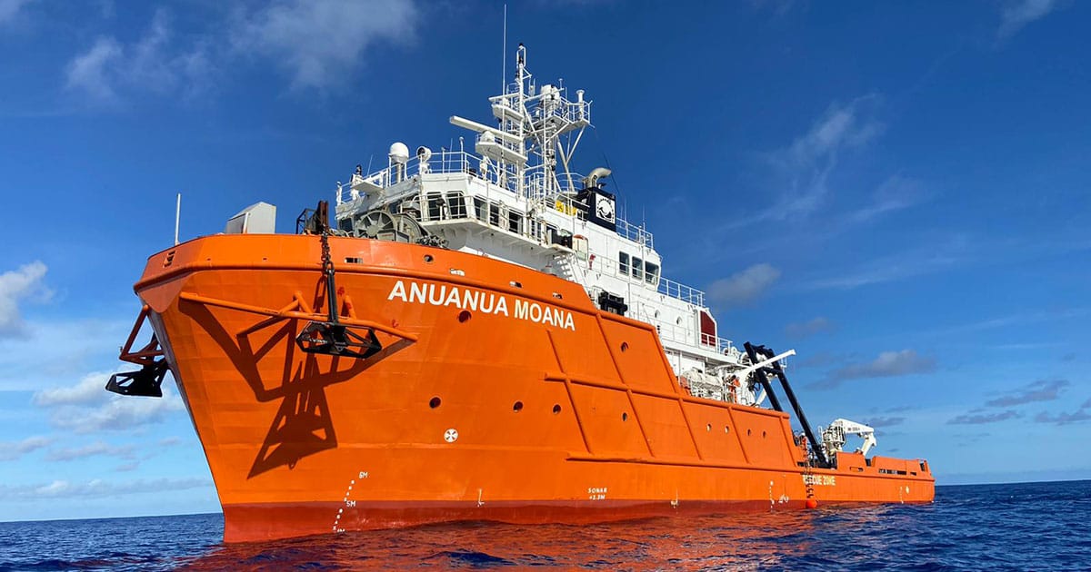
Originally built in 2007 and acquired in 2022 when comprehensively refurbished, the 196-foot (~60 meters) ship is a dedicated science platform for deep-sea minerals and serves as the core offshore platform for AOMC’s asset development. Upon completion of its previously announced merger with Odyssey, AOMC expects to hold approximately 80% to 100% of Ocean Minerals LLC (OML), which owns the Anuanua Moana through its wholly owned subsidiary Kiva Marine Ltd.
An Unmatched, Purpose-Built Platform
The vessel combines multiple workstreams on a single platform, avoiding the long mobilization and demobilization integration delays typical of chartered vessels. Equipped with permanently installed sonar systems, scientific echo sounders, subsea tracking technologies, and two A-frames, it deploys a range of equipment, including tow sleds, box cores, multi-cores, and dredges for bulk seafloor sampling.
It features three high-specification onboard laboratories (geology, chemistry, biology) alongside a 6,000-meter-rated remotely operated vehicle (ROV) for high-resolution imaging and sample collection. Configured to house up to 42 crew, scientists, and engineers, its fully cross-trained personnel ensure seamless, end-to-end productivity.
“The Anuanua Moana has been engineered and outfitted with modern equipment and capabilities for the next evolution of deep-sea minerals and environmental research,” said Hans Smit, President & CEO of Ocean Minerals LLC. “The vessel’s permanent deployment allows us to collect data on an ongoing basis, feeding into spatial and temporal data sets that are unparalleled in the industry.”
Smit brings over 30 years of deep ocean experience to the platform, having previously developed key engineering systems utilized by some of the world’s largest offshore diamond miners.
“AOMC is positioned to be a long-term supplier of the minerals we need to achieve American re-industrialization, and unlocking a portfolio of this scale requires dedicated infrastructure,” added Tom Albanese, Chairman of AOMC and former Rio Tinto CEO. “Access to this offshore asset will allow us to seamlessly advance both our Cook Islands and potential High Seas projects. This operational control ensures high environmental standards while accelerating our regulatory timelines.”
Executing the Pathway to Commercial Harvesting
Transitioning deep-sea mineral assets from exploration to commercial harvesting requires multi-year environmental baselining and resource definition. Through approved Work Plans, this data supports the completion of regulatory requirements for Mining License submittals, including Environmental Impact Statements (EIS) and Pre-Feasibility Studies (PFS).
AOMC’s environmental strategy relies on more than three years of consistent data collection that is near complete to remove data anomalies, establish a complete ecosystem picture detailing biodiversity, and ensure the absence of endemic species within any future mining plan. This data allows the building of a comprehensive “software model” of the environment to evaluate and quantify the impact of the operations.
“The importance of environmental baselining cannot be overstated,” said Katie Allen, Environmental Manager at Ocean Minerals LLC. “Collecting consistent data allows us to understand ecosystem structure and variability over time, which is essential to assessing potential impacts and ensuring that our permit and license applications to conduct minerals harvesting are grounded in robust science.”
Among its major milestones to date, the Anuanua Moana mapped the entire EL3 license area (more than 23,500 square kilometers) in 16 days. It subsequently completed a 30-day resource definition campaign, using ROV footage to confirm high-density nodule fields, contributing directly to a 2025 S-K 1300-compliant Technical Report on OML’s Mineral Resource Assessment that resulted in a mineral resource estimate of 417 million wet tonnes of polymetallic nodules at an indicated level of confidence and a further 102 million wet tonnes at an inferred level of confidence within EL3. The data collection across historical campaigns exceeds 3,700 hours of offshore work, 30 ROV deployments, 47 box core and 100 free-fall grab deployments, yielding more than 800 samples, and the bulk sampling of over 5 tonnes of polymetallic nodules.
Following these campaigns and utilizing the data collected, supported by additional data currently underway and planned, Moana Minerals has engaged AMC Consultants to review and provide third-party sign-off on its PFS this year, and ERIAS Group, an environmental and social impact assessment and management consultancy, to support its EIS. These key milestones are required for submitting an environmental project permit application, followed by the mining license application under Cook Islands regulations.
A Centralized Asset for a >500,000 km² Portfolio
The Anuanua Moana is planned for deployment as a centralized asset across an exploration footprint currently exceeding 500,000 square kilometers. This standardizes data collection processes and increases operational efficiency across Moana Minerals (EL3) and CIC Limited (CIC) license areas in the Cook Islands’ EEZ and US-regulated zones, including AOM Area 1 within the Clarion-Clipperton Zone and AOM Area 2 in the Penrhyn Basin.
Beyond internal use, the vessel’s specialized capabilities are sought after globally. Working on behalf of the University of Tokyo and funded by the Nippon Foundation, the vessel was instrumental in defining the extent of the nodule resource in Japanese territorial waters around Minamitorishima in 2024 and returned in late 2025 to execute the region’s first environmental campaign. In the Clarion- Clipperton Zone (CCZ), the vessel previously completed a 36-day campaign for Japan’s Deep Ocean Resources Development (DORD) in 2024, recovered scientific data and equipment for Global Sea Mineral Resources (GSR), and executed scientific work within the Interoceanmetal (IOM) license area. The vessel is also scheduled to support campaigns this year for other deep-sea exploration and development companies, including an upcoming 84-day deployment for DORD.
Tangible Community Impact
Beyond research, the vessel has been serving the Cook Islands community. Its continuous mapping data is actively used by locals to optimize Fish Aggregation Device (FAD) placements and by climate scientists to assess severe storm and tsunami risks.
The vessel also provides a unique platform for community and governmental engagement. Two voyages were specifically aimed at visiting the outer islands and incidentally mapping the seabed around and between the islands. By engaging with the remote island communities and bringing locals on board to witness ROV footage and scientific rigor firsthand, AOMC will actively operate with transparency and scientific data. The logistical benefits of such engagement were shared with the Cook Islands Minister of Seabed Minerals and Prime Minister Mark Brown and Seabed Minerals Authority (SBMA) staff who conducted parallel consultations on the state of the sector more generally.
“One of the big things we have to secure is the social license, and you have to engage with people who have questions about this industry,” added Smit. “We’ve not only gone out and engaged these communities who often feel isolated, but we’ve used the vessel as a way to show them the extent and magnitude of the science and work we do. People are often surprised by the level of detail and thoroughness of the work. It builds a level of trust and confidence that we’re advancing responsibly.”
The Anuanua Moana is currently deployed on a ROV-based megafauna survey campaign, analyzing 30 locations via 3-kilometer seafloor transect lines to identify visible marine life. A follow-on campaign will conduct targeted seafloor sampling to assess the benthic environment that includes microscopic animals in collaboration with scientists from multiple independent research organizations.